How digital mobility analytics can improve the appeal of active travel
Manchester City Centre Walkability Study

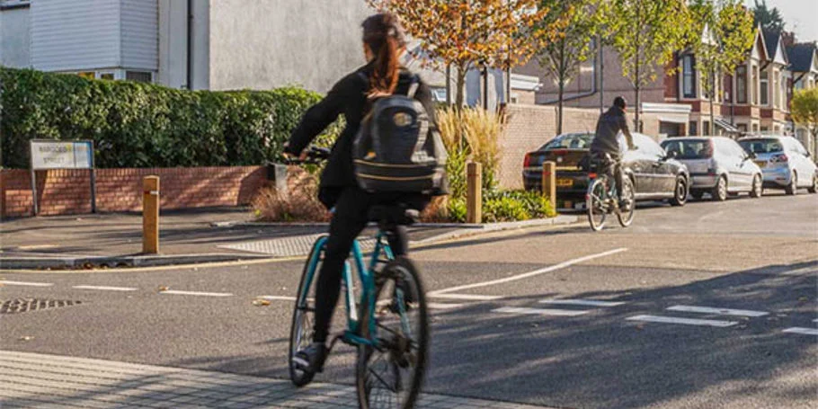
Manchester, UK has a fast-growing population and is one of the country’s most important commercial, retail and entertainment centres. The city authorities want to achieve a 70% increase in the number of trips into the city centre made by active modes by 2040.
Enabling more people to walk will support ambitions to reduce the amount of traffic in the city, providing air and noise quality improvements and making the city centre a safer environment for people to move around in. These environmental benefits will benefit specific groups in particular such as children and older people, making the city centre a more equitable and inclusive space.
Of course, to achieve this increase in walking and wheeling will require targeted and transformational improvements to the city centre walking network.
We were commissioned by Manchester City Council (MCC) to review the city centre walking network and develop a prioritised schedule of small-scale improvements. This includes the ensuring walkable connections between key attractions, reducing street clutter, providing crossings and junctions, and ensuring areas are safe and attractive during day and night.
The study area for the project covered the entire city centre of Manchester. On a tight programme, MCC needed a fast and efficient method to understand the locations that improvements would provide the most impact. To identify which improvements were needed where, it was first vital to understand how people currently moved around the city.

We used Staterra toolkit, our new digital toolkit to better understand pedestrian mobility and travel demand in cities and public realm. The tool draws on open source public mobility data, enabling us to review a large study area in a few short days and prioritise improvements based on key journey metrics and walkability analysis. Stakeholder engagement was central to the study, helping to make sure that there is both local and wider stakeholder buy-in to the proposals coming forward.

Using data to better understand pedestrian mobility
Staterra uses rich spatial data to answer the questions that shape planning decisions: why do people take this route? When do they travel? Where do they go to? How do they travel? The toolkit generates quick and flexible analysis without the need for detailed data collection.
Using Staterra provided a solid evidence base that would garner support for the project solutions. A person’s experience of a street is shaped by their own personal needs and abilities – Do they feel confident crossing a road? Do they have any accessibility needs? What gender are they? How old are they? Using the Staterra toolkit removed subjectivity from the analysis and provided the consistent and objective assessment our client was looking for.
Staterra: providing ongoing value
The project team has established a scalable methodology for MCC that can be repeated in future for small neighbourhoods or at a city scale. The Staterra analysis is able to provide MCC with an ongoing pipeline of priority locations for enhancement as and when funding for projects arise. The prioritisation is automated so can be quickly updated when significant changes and developments arise as the city evolves.
Read more about this project in the Arup Journal
Learn more about this project in issue 2 of the Arup Journal for 2023. Discover also innovative level crossing removal in Adelaide and designing a new education base in Nagoya.
Cities Alive: towards a walking world
Arup has an extensive catalogue of research exploring why walking is essential to creating a truly inclusive city which informed this project.

Projects
Explore more active travel projects
Improving the public transport experience for greater social inclusion
UK PACT Low Carbon Cities and Transport: Semarang, Indonesia, Indonesia

How can we enable more children to walk, wheel and cycle to school?
Oldham Safe and Active Schools, United Kingdom

Prescribing active travel for better health in Leeds
Leeds Active Travel Social Prescribing Pilot, United Kingdom

Designing a complex, sculptured bridge for Perth
Elizabeth Quay Pedestrian Bridge
Get in touch with us
If you'd like to speak to one of our roads and streets experts about any of the issues raised on this page or a potential collaboration then please get in touch by completing the form.